IMAGES TAKEN NEAR TO
Hinds Head Avenue, WIGAN, WN6 9RT
Introduction
This page details the photographs taken nearby to Hinds Head Avenue, WN6 9RT by members of the Geograph project.
The Geograph project started in 2005 with the aim of publishing, organising and preserving representative images for every square kilometre of Great Britain, Ireland and the Isle of Man.

There are currently over 7.5m images from over14,400 individuals and you can help contribute to the project by visiting https://www.geograph.org.uk
Image Map
Images are licensed for reuse under creativecommons.org/licenses/by-sa/2.0
Notes
- Clicking on the map will re-center to the selected point.
- The higher the marker number, the further away the image location is from the centre of the postcode.
Image Listing (16 Images Found)
Images are licensed for reuse under creativecommons.org/licenses/by-sa/2.0
Image
Details
Distance
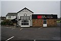
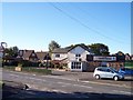
3

Rivaj of India, Mossy Lea
http://www.geograph.org.uk/photo/4495352
Image: © Ian S
Taken: 22 May 2015
0.06 miles
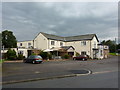
4
Rivaj of India, Mossy Lea
http://www.geograph.org.uk/photo/4495439
Image: © Ian S
Taken: 22 May 2015
0.06 miles
6
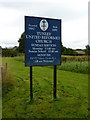
Tunley United Reformed Church, Sign
Image: © Alexander P Kapp
Taken: 13 Aug 2010
0.09 miles
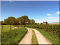
10
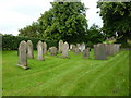
Tunley United Reformed Church, Graveyard
Image: © Alexander P Kapp
Taken: 13 Aug 2010
0.12 miles