IMAGES TAKEN NEAR TO
Robin Hood Lane, WIGAN, WN6 9QG
Introduction
This page details the photographs taken nearby to Robin Hood Lane, WN6 9QG by members of the Geograph project.
The Geograph project started in 2005 with the aim of publishing, organising and preserving representative images for every square kilometre of Great Britain, Ireland and the Isle of Man.

There are currently over 7.5m images from over14,400 individuals and you can help contribute to the project by visiting https://www.geograph.org.uk
Image Map
Images are licensed for reuse under creativecommons.org/licenses/by-sa/2.0
Notes
- Clicking on the map will re-center to the selected point.
- The higher the marker number, the further away the image location is from the centre of the postcode.
Image Listing (18 Images Found)
Images are licensed for reuse under creativecommons.org/licenses/by-sa/2.0
Image
Details
Distance
1
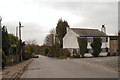
Robin Hood Lane
The Area's called Robin Hood, the farm's called Robin Hood and so is the lane. There was no-one around to ask why.
Image: © David Hignett
Taken: 1 Jun 2003
0.06 miles
3
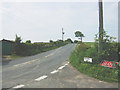
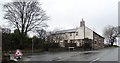
Robin Hood Lane
The road on the right is High Moor Lane
Image: © Raymond Knapman
Taken: 13 Oct 2010
0.12 miles
4
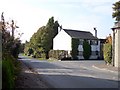
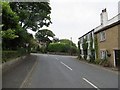
Robin Hood
The junction of Robin Hood Lane with High Moor Lane.
Image: © David Dixon
Taken: 22 Feb 2013
0.13 miles
7
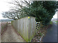
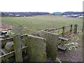
Footpath alternatives at Boars Den Farm
Image: © Gary Rogers
Taken: 20 Jan 2015
0.14 miles
8
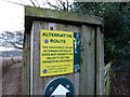
Alternative Route
Footpath information at Boar's Den farm
Image: © Gary Rogers
Taken: 20 Jan 2015
0.14 miles
9
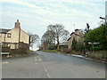
High Moor Lane junction at Robin Hood, Wrightington
Image: © Gary Rogers
Taken: 20 Jan 2015
0.16 miles