IMAGES TAKEN NEAR TO
Rookery Avenue, WIGAN, WN6 9JX
Introduction
This page details the photographs taken nearby to Rookery Avenue, WN6 9JX by members of the Geograph project.
The Geograph project started in 2005 with the aim of publishing, organising and preserving representative images for every square kilometre of Great Britain, Ireland and the Isle of Man.

There are currently over 7.5m images from over14,400 individuals and you can help contribute to the project by visiting https://www.geograph.org.uk
Image Map
Images are licensed for reuse under creativecommons.org/licenses/by-sa/2.0
Notes
- Clicking on the map will re-center to the selected point.
- The higher the marker number, the further away the image location is from the centre of the postcode.
Image Listing (9 Images Found)
Images are licensed for reuse under creativecommons.org/licenses/by-sa/2.0
Image
Details
Distance
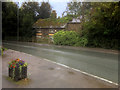
2
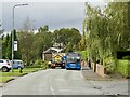
Back Lane, Shevington Vale
Drain cleaning and a no.635 bus
Image: © Richard Webb
Taken: 19 Oct 2021
0.14 miles
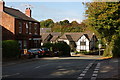
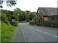
5
Old Cottage on Miles Lane, Shevington Vale
Image: © David Dixon
Taken: 6 Aug 2017
0.18 miles
6
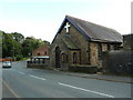
The Vale Methodist Church, Appley Bridge
Image: © Alexander P Kapp
Taken: 3 Oct 2012
0.18 miles

9
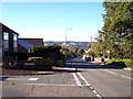
Back Lane, Shevington Vale
Hullet Close joins on the left
Image: © Raymond Knapman
Taken: 20 Oct 2010
0.22 miles