IMAGES TAKEN NEAR TO
Mill Lane, WIGAN, WN6 9DD
Introduction
This page details the photographs taken nearby to Mill Lane, WN6 9DD by members of the Geograph project.
The Geograph project started in 2005 with the aim of publishing, organising and preserving representative images for every square kilometre of Great Britain, Ireland and the Isle of Man.

There are currently over 7.5m images from over14,400 individuals and you can help contribute to the project by visiting https://www.geograph.org.uk
Image Map
Images are licensed for reuse under creativecommons.org/licenses/by-sa/2.0
Notes
- Clicking on the map will re-center to the selected point.
- The higher the marker number, the further away the image location is from the centre of the postcode.
Image Listing (26 Images Found)
Images are licensed for reuse under creativecommons.org/licenses/by-sa/2.0
Image
Details
Distance
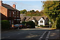
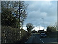
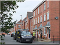
2
Old Cottage on Miles Lane, Shevington Vale
Image: © David Dixon
Taken: 6 Aug 2017
0.07 miles
5
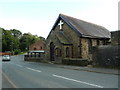
The Vale Methodist Church, Appley Bridge
Image: © Alexander P Kapp
Taken: 3 Oct 2012
0.21 miles
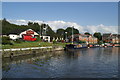
8
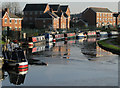
Leeds - Liverpool Canal at Appley Bridge
ice, narrowboats and recent housing development.
Image: © Gary Rogers
Taken: 23 Dec 2007
0.22 miles
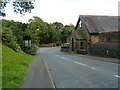
9
Window Cleaners at Heron's Wharf, Appley Bridge
Wrightington Windows
Image: © Gary Rogers
Taken: 23 Sep 2017
0.22 miles