IMAGES TAKEN NEAR TO
Gidlow Lane, WIGAN, WN6 8RX
Introduction
This page details the photographs taken nearby to Gidlow Lane, WN6 8RX by members of the Geograph project.
The Geograph project started in 2005 with the aim of publishing, organising and preserving representative images for every square kilometre of Great Britain, Ireland and the Isle of Man.

There are currently over 7.5m images from over14,400 individuals and you can help contribute to the project by visiting https://www.geograph.org.uk
Image Map
Images are licensed for reuse under creativecommons.org/licenses/by-sa/2.0
Notes
- Clicking on the map will re-center to the selected point.
- The higher the marker number, the further away the image location is from the centre of the postcode.
Image Listing (11 Images Found)
Images are licensed for reuse under creativecommons.org/licenses/by-sa/2.0
Image
Details
Distance

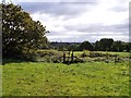
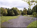
4
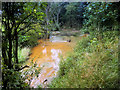
Slag heaps and reminders of Giant's Hall Colliery
Slag has been landscaped, but remnants of colliery activity remain
Image: © Raymond Knapman
Taken: 24 Sep 2010
0.11 miles
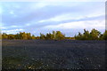
6
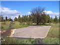
Site of Standish colliery railway and Giant's Hall Colliery
The railway served the collieries around Standish and ran to the sidings on the West Coast Main Line
Image: © Raymond Knapman
Taken: 24 Sep 2010
0.19 miles