IMAGES TAKEN NEAR TO
Willow Road, WIGAN, WN6 8QP
Introduction
This page details the photographs taken nearby to Willow Road, WN6 8QP by members of the Geograph project.
The Geograph project started in 2005 with the aim of publishing, organising and preserving representative images for every square kilometre of Great Britain, Ireland and the Isle of Man.

There are currently over 7.5m images from over14,400 individuals and you can help contribute to the project by visiting https://www.geograph.org.uk
Image Map
Images are licensed for reuse under creativecommons.org/licenses/by-sa/2.0
Notes
- Clicking on the map will re-center to the selected point.
- The higher the marker number, the further away the image location is from the centre of the postcode.
Image Listing (8 Images Found)
Images are licensed for reuse under creativecommons.org/licenses/by-sa/2.0
Image
Details
Distance
5
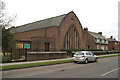
St Anne's Church and Vicarage, Beech Hill
Image: © David Long
Taken: 21 Feb 2009
0.17 miles
6
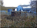
We'll leave this in place...........just in case.
In the foreground the brambles almost obscure an old World War 2 Pillbox.The factory in the background was the former R.O.F at Beech Hill.There are several of these Mini Forts and Air Raid shelters around the perimeter fence.
Image: © Jimmy Reeves
Taken: 2 Mar 2006
0.19 miles
7
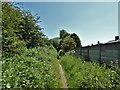
Bridleway on route of former railway
A route of a mineral railway which is here up against the gardens of Acacia Crescent. It served among others Giant's Hall colliery.
Image: © Kevin Waterhouse
Taken: 5 Jun 2023
0.20 miles
8
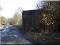
Pillbox watches over the abandoned railway
Another pic in same location but slightly West of other. The abandoned line went to Giants Hall, John, Taylor and Standish Hall Coal Mines which were to the West. The view is looking East towards Rylands Siding and the West Coast Main Line.
Image: © Jimmy Reeves
Taken: 2 Mar 2006
0.23 miles