IMAGES TAKEN NEAR TO
Wingfield Close, WIGAN, WN6 8QL
Introduction
This page details the photographs taken nearby to Wingfield Close, WN6 8QL by members of the Geograph project.
The Geograph project started in 2005 with the aim of publishing, organising and preserving representative images for every square kilometre of Great Britain, Ireland and the Isle of Man.

There are currently over 7.5m images from over14,400 individuals and you can help contribute to the project by visiting https://www.geograph.org.uk
Image Map
Images are licensed for reuse under creativecommons.org/licenses/by-sa/2.0
Notes
- Clicking on the map will re-center to the selected point.
- The higher the marker number, the further away the image location is from the centre of the postcode.
Image Listing (16 Images Found)
Images are licensed for reuse under creativecommons.org/licenses/by-sa/2.0
Image
Details
Distance
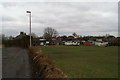
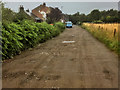
2
Fields, Brimelow Farm, Beech Hill
The massive and intrusive Heinz factory at Kitt Green is in the distance.
Image: © David Long
Taken: 21 Feb 2009
0.04 miles
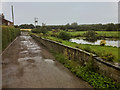
7
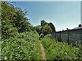
Bridleway on route of former railway
A route of a mineral railway which is here up against the gardens of Acacia Crescent. It served among others Giant's Hall colliery.
Image: © Kevin Waterhouse
Taken: 5 Jun 2023
0.11 miles
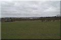
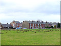
8
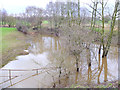
Flooded corner of field near Giant's Hall, Standish Lower Ground
Image: © Gary Rogers
Taken: 4 Mar 2017
0.13 miles
9
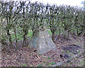
Mine Shaft Cap South West of Gidlow Cemetery
Image: © Gary Rogers
Taken: 4 Mar 2017
0.17 miles
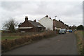
10
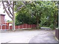
Entrance to Bridleway off Acacia Crescent
Image: © Raymond Knapman
Taken: 24 Sep 2010
0.18 miles