IMAGES TAKEN NEAR TO
Paddock Rise, WIGAN, WN6 8QB
Introduction
This page details the photographs taken nearby to Paddock Rise, WN6 8QB by members of the Geograph project.
The Geograph project started in 2005 with the aim of publishing, organising and preserving representative images for every square kilometre of Great Britain, Ireland and the Isle of Man.

There are currently over 7.5m images from over14,400 individuals and you can help contribute to the project by visiting https://www.geograph.org.uk
Image Map
Images are licensed for reuse under creativecommons.org/licenses/by-sa/2.0
Notes
- Clicking on the map will re-center to the selected point.
- The higher the marker number, the further away the image location is from the centre of the postcode.
Image Listing (33 Images Found)
Images are licensed for reuse under creativecommons.org/licenses/by-sa/2.0
Image
Details
Distance
1
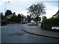
Beech Hill Avenue/Beech Hill Lane junction
Image: © Colin Pyle
Taken: 26 Sep 2012
0.11 miles
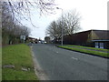
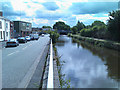
4

Houses on Scot Lane, Wigan
Semi-detached housing on Scot Lane, in Wigan, Greater Manchester, England.
Image: © Steven Haslington
Taken: 5 Nov 2012
0.14 miles


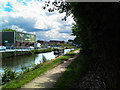
7
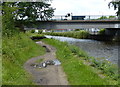
Scot Lane Bridge No 49aa
Crossing the Leeds and Liverpool Canal in Wigan.
Image: © Mat Fascione
Taken: 27 Jun 2016
0.18 miles
10
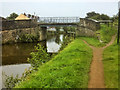
Leeds and Liverpool Canal, Martland Mill Bridge
Bridge number 49 on the Leeds and Liverpool Canal, at Standish Lower Ground.
Image: © David Dixon
Taken: 6 Aug 2017
0.19 miles