IMAGES TAKEN NEAR TO
Elmfield, WIGAN, WN6 8DL
Introduction
This page details the photographs taken nearby to Elmfield, WN6 8DL by members of the Geograph project.
The Geograph project started in 2005 with the aim of publishing, organising and preserving representative images for every square kilometre of Great Britain, Ireland and the Isle of Man.

There are currently over 7.5m images from over14,400 individuals and you can help contribute to the project by visiting https://www.geograph.org.uk
Image Map
Images are licensed for reuse under creativecommons.org/licenses/by-sa/2.0
Notes
- Clicking on the map will re-center to the selected point.
- The higher the marker number, the further away the image location is from the centre of the postcode.
Image Listing (9 Images Found)
Images are licensed for reuse under creativecommons.org/licenses/by-sa/2.0
Image
Details
Distance
2
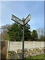
Direction Sign ? Signpost in Shevington
Located on the west side of the T junction of the B5375 Wigan Road/Church Lane and Old Lane in Shevington parish. 3 arms and no finial.
Milestone Society National ID: LA_SD5408
Image: © W MacDonald
Taken: 12 Nov 2020
0.11 miles
4
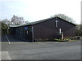
St Bernadette's Catholic Church, Shevington
Image: © JThomas
Taken: 16 Feb 2013
0.13 miles