IMAGES TAKEN NEAR TO
Longbrook, WIGAN, WN6 8DA
Introduction
This page details the photographs taken nearby to Longbrook, WN6 8DA by members of the Geograph project.
The Geograph project started in 2005 with the aim of publishing, organising and preserving representative images for every square kilometre of Great Britain, Ireland and the Isle of Man.

There are currently over 7.5m images from over14,400 individuals and you can help contribute to the project by visiting https://www.geograph.org.uk
Image Map
Images are licensed for reuse under creativecommons.org/licenses/by-sa/2.0
Notes
- Clicking on the map will re-center to the selected point.
- The higher the marker number, the further away the image location is from the centre of the postcode.
Image Listing (8 Images Found)
Images are licensed for reuse under creativecommons.org/licenses/by-sa/2.0
Image
Details
Distance
4
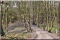
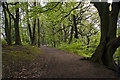
Mill Dam Wood, Shevington
Mill Dam wood, Easter Sunday, April 2010
Image: © Edward Marshall
Taken: 4 Apr 2010
0.17 miles
5
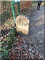
Old Boundary Marker in Elnup Wood
Estate Boundary Marker re-erected at the side of a woodland path outside Mill Dam Cottages in Elnup Wood between Standish and Shevington. Inscribed E T S / 1806 and T D H / 1806 on opposite faces. Its original location is unknown. It lay for many years in Mill Brook, the boundary between Standish with Langtree parish and Shevington parish. Research has revealed it is the marker for the boundary between land owned by “ETS” Edward Towneley Standish, the Lord of Standish Manor from 1778 to 1807 and “TDH” Sir Thomas Dalrymple Hesketh, the 3rd Baronet Hesketh of Rufford from 1796 to 1842, who owned land in Shevington.
Milestone Society National ID: LA_STAN01em
Image: © W Aldridge
Taken: 19 Nov 2020
0.18 miles
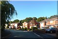
6
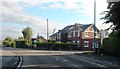
New Housing Development on Shevington Lane
Image: © Anthony Parkes
Taken: 3 Jul 2013
0.19 miles
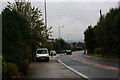
7
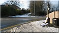
Shevington Lane
Looking across Shevington Lane from Parbrook Lane. The footpath sign is puzzling, it points down Parbrook Lane, a residential street and obvious road. England's weird rights of way hierarchy continues to baffle - must keep a few in a job.
The foreground is car parking for a corner shop.
Image: © Richard Webb
Taken: 27 Dec 2009
0.22 miles