IMAGES TAKEN NEAR TO
Hollinbrook, WIGAN, WN6 7SG
Introduction
This page details the photographs taken nearby to Hollinbrook, WN6 7SG by members of the Geograph project.
The Geograph project started in 2005 with the aim of publishing, organising and preserving representative images for every square kilometre of Great Britain, Ireland and the Isle of Man.

There are currently over 7.5m images from over14,400 individuals and you can help contribute to the project by visiting https://www.geograph.org.uk
Image Map
Images are licensed for reuse under creativecommons.org/licenses/by-sa/2.0
Notes
- Clicking on the map will re-center to the selected point.
- The higher the marker number, the further away the image location is from the centre of the postcode.
Image Listing (23 Images Found)
Images are licensed for reuse under creativecommons.org/licenses/by-sa/2.0
Image
Details
Distance

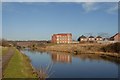
8

The Leeds Liverpool canal at Beech Hill lock
Image: © Ian Greig
Taken: 8 Jul 2010
0.20 miles
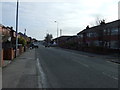
9
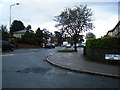
Beech Hill Avenue/Beech Hill Lane junction
Image: © Colin Pyle
Taken: 26 Sep 2012
0.20 miles
10

Leeds & Liverpool Canal
At lock 89, Ell Meadow Lock.
Image: © Ian S
Taken: 10 Jun 2019
0.20 miles