IMAGES TAKEN NEAR TO
Barnsley Street, WIGAN, WN6 7HZ
Introduction
This page details the photographs taken nearby to Barnsley Street, WN6 7HZ by members of the Geograph project.
The Geograph project started in 2005 with the aim of publishing, organising and preserving representative images for every square kilometre of Great Britain, Ireland and the Isle of Man.

There are currently over 7.5m images from over14,400 individuals and you can help contribute to the project by visiting https://www.geograph.org.uk
Image Map
Images are licensed for reuse under creativecommons.org/licenses/by-sa/2.0
Notes
- Clicking on the map will re-center to the selected point.
- The higher the marker number, the further away the image location is from the centre of the postcode.
Image Listing (15 Images Found)
Images are licensed for reuse under creativecommons.org/licenses/by-sa/2.0
Image
Details
Distance
3
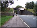
The West Coast Main Line crosses Walkden Avenue
Image: © Raymond Knapman
Taken: 24 Sep 2010
0.10 miles
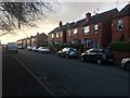
4
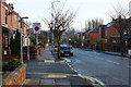
Running repairs to mini roundabout at Gidlow Lane
Image: © Raymond Knapman
Taken: 24 Sep 2010
0.11 miles
5
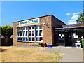
Book Cycle
At the old library on Buckley Street off Gidlow Lane
Image: © Gary Rogers
Taken: 8 Jul 2018
0.14 miles
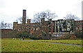
8
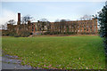
Pagefield Mill
The Pagefield Building of Wigan College of Technology was built in 1867, for
John Rylands, one of the area's largest cotton manufacturers. The Grade II
listed complex includes the former spinning mill, weaving sheds
and engine house and chimney.
Image: © David Dixon
Taken: 12 Jan 2013
0.24 miles
9
Gidlow Mill (also known as Rylands Mill)
A grave disappointment - an enormous grade II listed integrated cotton mill complex dating back to 1863-65 but derelict, inaccessible, surrounded by trees and just lacking a decent photographic angle. It had been at least partly used by a technical college but had then been abandoned. The aerial photo is most impressive.
Image: © Chris Allen
Taken: 23 Jan 2011
0.24 miles
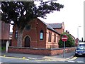
10
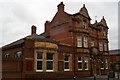
The Springfield, on the corner of Springfield Road and Rylands Avenue
Image: © David Long
Taken: 21 Feb 2009
0.24 miles