IMAGES TAKEN NEAR TO
Hillreed, WIGAN, WN6 7EW
Introduction
This page details the photographs taken nearby to Hillreed, WN6 7EW by members of the Geograph project.
The Geograph project started in 2005 with the aim of publishing, organising and preserving representative images for every square kilometre of Great Britain, Ireland and the Isle of Man.

There are currently over 7.5m images from over14,400 individuals and you can help contribute to the project by visiting https://www.geograph.org.uk
Image Map
Images are licensed for reuse under creativecommons.org/licenses/by-sa/2.0
Notes
- Clicking on the map will re-center to the selected point.
- The higher the marker number, the further away the image location is from the centre of the postcode.
Image Listing (25 Images Found)
Images are licensed for reuse under creativecommons.org/licenses/by-sa/2.0
Image
Details
Distance
2
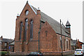
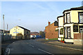
East end, St Andrew's Parish Church, Mort Street, Springfield
Image: © David Long
Taken: 21 Feb 2009
0.07 miles
4
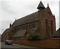
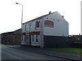
West end, St Andrew's Parish Church, Mort Street, Springfield
Image: © David Long
Taken: 21 Feb 2009
0.08 miles
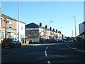
5
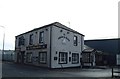
Spoilt for choice
Three pubs on one corner!
Image: © David Long
Taken: 20 Nov 2005
0.11 miles

8
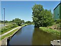
Leeds and Liverpool Canal
Viewed from the footbridge of Pagefield lock No.88
Image: © Kevin Waterhouse
Taken: 5 Jun 2023
0.18 miles
10
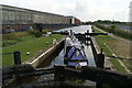
Pagefield Lock, Leeds & Liverpool Canal main line, Wigan
Image: © David Long
Taken: 12 Sep 2007
0.18 miles