IMAGES TAKEN NEAR TO
Pagefield Street, WIGAN, WN6 7ED
Introduction
This page details the photographs taken nearby to Pagefield Street, WN6 7ED by members of the Geograph project.
The Geograph project started in 2005 with the aim of publishing, organising and preserving representative images for every square kilometre of Great Britain, Ireland and the Isle of Man.

There are currently over 7.5m images from over14,400 individuals and you can help contribute to the project by visiting https://www.geograph.org.uk
Image Map
Images are licensed for reuse under creativecommons.org/licenses/by-sa/2.0
Notes
- Clicking on the map will re-center to the selected point.
- The higher the marker number, the further away the image location is from the centre of the postcode.
Image Listing (12 Images Found)
Images are licensed for reuse under creativecommons.org/licenses/by-sa/2.0
Image
Details
Distance
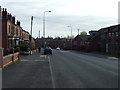
2
Sillitoe Drive, Wigan
Always wanted to see this drive.
Image: © Alan Sillitoe
Taken: 23 Mar 2013
0.15 miles
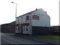
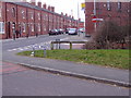
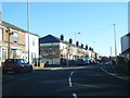
4
The Springfield, on the corner of Springfield Road and Rylands Avenue
Image: © David Long
Taken: 21 Feb 2009
0.20 miles
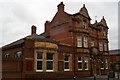
6
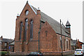
East end, St Andrew's Parish Church, Mort Street, Springfield
Image: © David Long
Taken: 21 Feb 2009
0.22 miles
8
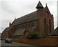
West end, St Andrew's Parish Church, Mort Street, Springfield
Image: © David Long
Taken: 21 Feb 2009
0.22 miles
9
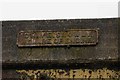
Old Sign on bridge
This bridge carries the Wigan to Southport line over what was formerly also a railway line. Today there is only a footpath from Beresford Street to Miry Lane.
This sign is on the Beresford St side of the bridge.
Image: © Galatas
Taken: 17 Feb 2011
0.23 miles
10
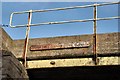
Old sign on bridge
This bridge carries the Wigan to Southport line over what was formerly also a railway line. Today there is only a footpath from Beresford Street to Miry Lane.
This sign is on the Miry lane side of the bridge.
Image: © Galatas
Taken: 16 Feb 2011
0.23 miles