IMAGES TAKEN NEAR TO
Meadowacre, WIGAN, WN6 0US
Introduction
This page details the photographs taken nearby to Meadowacre, WN6 0US by members of the Geograph project.
The Geograph project started in 2005 with the aim of publishing, organising and preserving representative images for every square kilometre of Great Britain, Ireland and the Isle of Man.

There are currently over 7.5m images from over14,400 individuals and you can help contribute to the project by visiting https://www.geograph.org.uk
Image Map
Images are licensed for reuse under creativecommons.org/licenses/by-sa/2.0
Notes
- Clicking on the map will re-center to the selected point.
- The higher the marker number, the further away the image location is from the centre of the postcode.
Image Listing (13 Images Found)
Images are licensed for reuse under creativecommons.org/licenses/by-sa/2.0
Image
Details
Distance
1
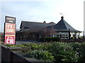
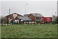
Shevington Moor - Britannia Hotel Entrance
Wikipedia : https://en.wikipedia.org/wiki/Britannia_Hotels
Image: © James Emmans
Taken: 16 Apr 2017
0.17 miles
3
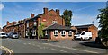
Foresters Arms
Foresters Arms public house.
Image: © Peter McDermott
Taken: 7 Jul 2023
0.18 miles
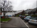
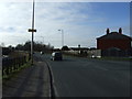
4
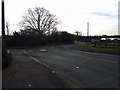
Almond Brook Road
Link between Standish and the M6.
Image: © Richard Webb
Taken: 3 Apr 2015
0.20 miles
5
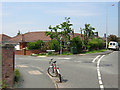
Old Pepper Lane
A brick postbox lodges uneasily on the sweeping corner which forms the junction between Old Pepper Lane and Pepper Lane.
Image: © David Hignett
Taken: 1 Jun 2003
0.20 miles
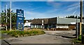
6
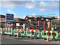
Cat i' th' Window Housing Development
Almond Brook Road, Standish
Image: © Gary Rogers
Taken: 15 Mar 2016
0.20 miles
9

Charnley Arms, Shevington Moor
Restaurant and pub on Almond Brook Road, Shevington Moor.
Image: © David Dixon
Taken: 25 Sep 2010
0.22 miles