IMAGES TAKEN NEAR TO
Broadacre, WIGAN, WN6 0SN
Introduction
This page details the photographs taken nearby to Broadacre, WN6 0SN by members of the Geograph project.
The Geograph project started in 2005 with the aim of publishing, organising and preserving representative images for every square kilometre of Great Britain, Ireland and the Isle of Man.

There are currently over 7.5m images from over14,400 individuals and you can help contribute to the project by visiting https://www.geograph.org.uk
Image Map
Images are licensed for reuse under creativecommons.org/licenses/by-sa/2.0
Notes
- Clicking on the map will re-center to the selected point.
- The higher the marker number, the further away the image location is from the centre of the postcode.
Image Listing (13 Images Found)
Images are licensed for reuse under creativecommons.org/licenses/by-sa/2.0
Image
Details
Distance
1
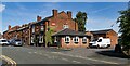
Foresters Arms
Foresters Arms public house.
Image: © Peter McDermott
Taken: 7 Jul 2023
0.10 miles
2
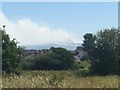
Winter Hill seen from Shevington Moor
A pair of moorland fires are about to merge. Much of the moorland on Winter Hill was on fire and the smoke extended to the coast.
Image: © Richard Webb
Taken: 30 Jun 2018
0.14 miles
3
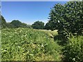
Path, Shevington Moor
A field on the edge of an urban area, nor in agricultural use. The smoke from moorland fires on Winter Hill is visible.
Image: © Richard Webb
Taken: 30 Jun 2018
0.15 miles

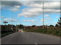
7
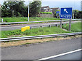
Slip road to B5209 for Wigan from M6 south Junc 27
Image: © John Firth
Taken: 13 May 2011
0.20 miles
9
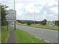
The Bridge to Nowhere
If you head towards Wigan from the M6 Jn27, you can see the original plan was to build a nice new road to bypass sleepy Standish. They even built a bridge to carry the A5209 over this new highway, which no-one seemed keen to pay for. The result is known locally as the "Bridge to Nowhere", but should more accurately be known as the bridge over nothing!
Image: © David Hignett
Taken: 3 Aug 2005
0.22 miles
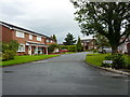
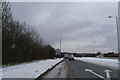
10
Crow Orchard Road (A5209), Shevington Moor
Image: © David Dixon
Taken: 25 Sep 2010
0.22 miles