IMAGES TAKEN NEAR TO
Witham Close, WIGAN, WN6 0RD
Introduction
This page details the photographs taken nearby to Witham Close, WN6 0RD by members of the Geograph project.
The Geograph project started in 2005 with the aim of publishing, organising and preserving representative images for every square kilometre of Great Britain, Ireland and the Isle of Man.

There are currently over 7.5m images from over14,400 individuals and you can help contribute to the project by visiting https://www.geograph.org.uk
Image Map
Images are licensed for reuse under creativecommons.org/licenses/by-sa/2.0
Notes
- Clicking on the map will re-center to the selected point.
- The higher the marker number, the further away the image location is from the centre of the postcode.
Image Listing (44 Images Found)
Images are licensed for reuse under creativecommons.org/licenses/by-sa/2.0
Image
Details
Distance
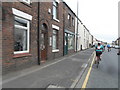
1
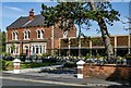
Albert's Restaurant
Restaurant in Standish.
Image: © Peter McDermott
Taken: 7 Jul 2023
0.04 miles
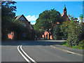
3
Green Lane, Standish
Green Lane, approaching the junction with School Lane (A5209)
Image: © David Dixon
Taken: 25 Sep 2010
0.05 miles
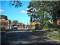
4
Box Junction at School Lane and Green Lane, Standish
Image: © Gary Rogers
Taken: 15 Mar 2016
0.06 miles
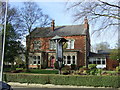
6
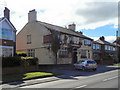
Dog & Partridge
Former public house on School Lane, Standish.
Image: © David Dixon
Taken: 25 Sep 2010
0.10 miles
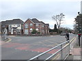
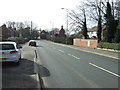
8
School Lane - Almond Brook Road (A5209)
The sharp bend in the A5209, where it changes from School Lane to Almond Brook Road. Ahead is the Catholic Church of Saint Marie of the Annunciation.
Image: © David Dixon
Taken: 25 Sep 2010
0.14 miles
10
Catholic Church of St Marie of the Annunciation
Image: © JThomas
Taken: 16 Feb 2013
0.14 miles