IMAGES TAKEN NEAR TO
Hyatt Crescent, WIGAN, WN6 0PU
Introduction
This page details the photographs taken nearby to Hyatt Crescent, WN6 0PU by members of the Geograph project.
The Geograph project started in 2005 with the aim of publishing, organising and preserving representative images for every square kilometre of Great Britain, Ireland and the Isle of Man.

There are currently over 7.5m images from over14,400 individuals and you can help contribute to the project by visiting https://www.geograph.org.uk
Image Map
Images are licensed for reuse under creativecommons.org/licenses/by-sa/2.0
Notes
- Clicking on the map will re-center to the selected point.
- The higher the marker number, the further away the image location is from the centre of the postcode.
Image Listing (9 Images Found)
Images are licensed for reuse under creativecommons.org/licenses/by-sa/2.0
Image
Details
Distance
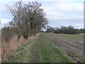
2
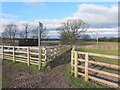
Footpath from Thompson House to Langtree Old Hall Farm
Image: © Gary Rogers
Taken: 15 Mar 2016
0.13 miles
4
Path from Thompson House Solar Farm to Langtree Old Hall Farm
Image: © Gary Rogers
Taken: 15 Mar 2016
0.21 miles
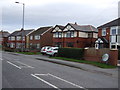
5
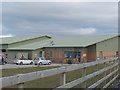
Thompson House Equestrian Centre, Standish
Image: © Gary Rogers
Taken: 15 Mar 2016
0.22 miles
6
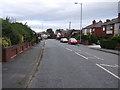
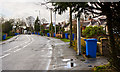
Pepper Lane, Shevington Moor
Heading east towards the A49.
Image: © JThomas
Taken: 25 Oct 2014
0.23 miles
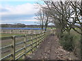
7
Path to Preston Road near Chadwick Farm
Image: © Gary Rogers
Taken: 15 Mar 2016
0.24 miles

9
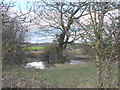
One of the small ponds near Chadwick Farm
Image: © Gary Rogers
Taken: 15 Mar 2016
0.25 miles