IMAGES TAKEN NEAR TO
Greenwood Road, WIGAN, WN6 0NL
Introduction
This page details the photographs taken nearby to Greenwood Road, WN6 0NL by members of the Geograph project.
The Geograph project started in 2005 with the aim of publishing, organising and preserving representative images for every square kilometre of Great Britain, Ireland and the Isle of Man.

There are currently over 7.5m images from over14,400 individuals and you can help contribute to the project by visiting https://www.geograph.org.uk
Image Map
Images are licensed for reuse under creativecommons.org/licenses/by-sa/2.0
Notes
- Clicking on the map will re-center to the selected point.
- The higher the marker number, the further away the image location is from the centre of the postcode.
Image Listing (72 Images Found)
Images are licensed for reuse under creativecommons.org/licenses/by-sa/2.0
Image
Details
Distance
3
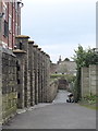
Footpath from Rectory Lane to Bentham Road
Image: © Gary Rogers
Taken: 15 Mar 2016
0.13 miles
7

Modern Waymarker, Standish
Carved stone post by the B5239, in parish of Standish (Wigan District), Bridle Road; Standish, erected in the 20th century.
Inscription reads:-
BRIDLE / ROAD / Standish / to / Hic Bibi / 1 ½ miles
Milestone Society National ID: LA_XSTAN
Image: © Christopher Leather
Taken: 29 Dec 2024
0.15 miles
9
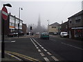
Market Street, Standish
On a misty March morning. St. Wilfrid's C. of E. parish church steeple looms in the background.
Image: © philandju
Taken: 6 Mar 2012
0.16 miles
10
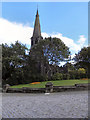
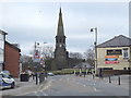
St.Wilfrid?s Parish Church
Grade I listed church, viewed from Market Place.
http://www.wigan.gov.uk/NR/rdonlyres/8772E80C-D50F-4797-8F03-AE6314AED127/0/StandishPartFive750kb.pdf gives a history of the church, together with a description of its architectural features.
Image: © David Dixon
Taken: 25 Sep 2010
0.16 miles