IMAGES TAKEN NEAR TO
Preston Road, WIGAN, WN6 0JF
Introduction
This page details the photographs taken nearby to Preston Road, WN6 0JF by members of the Geograph project.
The Geograph project started in 2005 with the aim of publishing, organising and preserving representative images for every square kilometre of Great Britain, Ireland and the Isle of Man.

There are currently over 7.5m images from over14,400 individuals and you can help contribute to the project by visiting https://www.geograph.org.uk
Image Map
Images are licensed for reuse under creativecommons.org/licenses/by-sa/2.0
Notes
- Clicking on the map will re-center to the selected point.
- The higher the marker number, the further away the image location is from the centre of the postcode.
Image Listing (13 Images Found)
Images are licensed for reuse under creativecommons.org/licenses/by-sa/2.0
Image
Details
Distance
5
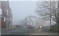
Standish in the fog
Fire Station Road, Pole Street, junction.
Image: © Richard Webb
Taken: 19 Dec 2021
0.21 miles
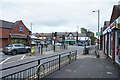
7
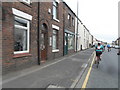
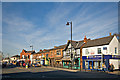
Shops in Standish
Shops on School Street and Market Street in Standish.
Image: © Philip Halling
Taken: 24 Jun 2019
0.24 miles
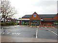
8
Standish town
A busy crossroads with a difficult pull out into traffic from the car park of the Spar supermarket.
Image: © Malcolm Neal
Taken: 4 Oct 2021
0.24 miles
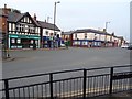
10
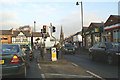
A49 crossroads, Standish
An unusual feature of this junction in such an old settlement is that there is no pub on any of the corners.
Image: © David Long
Taken: 29 Dec 2008
0.24 miles