IMAGES TAKEN NEAR TO
Malt Kiln Mews, WIGAN, WN6 0GJ
Introduction
This page details the photographs taken nearby to Malt Kiln Mews, WN6 0GJ by members of the Geograph project.
The Geograph project started in 2005 with the aim of publishing, organising and preserving representative images for every square kilometre of Great Britain, Ireland and the Isle of Man.

There are currently over 7.5m images from over14,400 individuals and you can help contribute to the project by visiting https://www.geograph.org.uk
Image Map
Images are licensed for reuse under creativecommons.org/licenses/by-sa/2.0
Notes
- Clicking on the map will re-center to the selected point.
- The higher the marker number, the further away the image location is from the centre of the postcode.
Image Listing (95 Images Found)
Images are licensed for reuse under creativecommons.org/licenses/by-sa/2.0
Image
Details
Distance
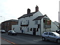
4
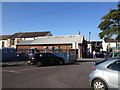
Car Park of La Mama Restaurant, Standish
Image: © Richard Cooke
Taken: 21 Jun 2014
0.04 miles
5
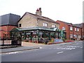
The 1817 Emporium on the High Street
Image: © Raymond Knapman
Taken: 24 Sep 2010
0.05 miles

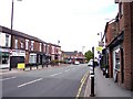
10
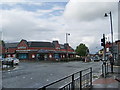
Road junction centre of Standish
The junction of A5209, A49 and B5239
Image: © Alexander P Kapp
Taken: 2 Sep 2008
0.09 miles