IMAGES TAKEN NEAR TO
Glebe Road, WIGAN, WN6 0DB
Introduction
This page details the photographs taken nearby to Glebe Road, WN6 0DB by members of the Geograph project.
The Geograph project started in 2005 with the aim of publishing, organising and preserving representative images for every square kilometre of Great Britain, Ireland and the Isle of Man.

There are currently over 7.5m images from over14,400 individuals and you can help contribute to the project by visiting https://www.geograph.org.uk
Image Map
Images are licensed for reuse under creativecommons.org/licenses/by-sa/2.0
Notes
- Clicking on the map will re-center to the selected point.
- The higher the marker number, the further away the image location is from the centre of the postcode.
Image Listing (64 Images Found)
Images are licensed for reuse under creativecommons.org/licenses/by-sa/2.0
Image
Details
Distance

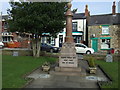
3
Standish war memorial
At the far end of the memorial garden is a drinking fountain erected to celebrate Queen Victoria's diamond jubilee, 1897.
Image: © philandju
Taken: 6 Mar 2012
0.11 miles
4
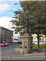
Queen Victoria Jubilee Drinking Fountain
This Grade II listed drinking fountain was erected in 1897 to commemorate Queen Victoria's Diamond Jubilee. It is at the junction of High Street and Church Street, at the apex of Image The fountain consists of a square section stone column with chamfered corners. Marble basins are fed by lion head spouts. The tapered stonework top is surmounted by an ornate cast iron lamp standard with reproduction lantern.
Image: © David Dixon
Taken: 25 Sep 2010
0.11 miles
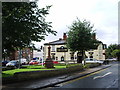
5

Queen Victoria Jubilee Gardens
A small triangular green, located at the forked junction of High Street and Church Street. The Grade II listed Image], erected in 1897, stands at the apex of the gardens. Behind it, at the centre of the gardens, is Image
Image: © David Dixon
Taken: 25 Sep 2010
0.12 miles
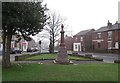
6
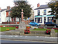
Queen Victoria Jubilee Gardens and War Memorial
The Queen Victoria Jubilee Garden is a small triangular green, located at the forked junction of High Street and Church Street. Centrally placed within the gardens is Standish War Memorial erected 1920 and unusual in its inscription 1914-19 acknowledging that hostilities continued in other theatres after the 1918 Armistice.
Image: © David Dixon
Taken: 25 Sep 2010
0.12 miles
7

Standish War Memorial
The War Memorial, erected in 1920 in the centre of Image It is unusual in its inscription 1914-19 acknowledging that hostilities continued in other theatres after the 1918 Armistice.
Image: © David Dixon
Taken: 25 Sep 2010
0.12 miles