IMAGES TAKEN NEAR TO
School Way, WIGAN, WN5 9TQ
Introduction
This page details the photographs taken nearby to School Way, WN5 9TQ by members of the Geograph project.
The Geograph project started in 2005 with the aim of publishing, organising and preserving representative images for every square kilometre of Great Britain, Ireland and the Isle of Man.

There are currently over 7.5m images from over14,400 individuals and you can help contribute to the project by visiting https://www.geograph.org.uk
Image Map
Images are licensed for reuse under creativecommons.org/licenses/by-sa/2.0
Notes
- Clicking on the map will re-center to the selected point.
- The higher the marker number, the further away the image location is from the centre of the postcode.
Image Listing (7 Images Found)
Images are licensed for reuse under creativecommons.org/licenses/by-sa/2.0
Image
Details
Distance
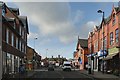
1
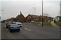
Ormskirk Road in Pemberton
This is the junction with Norley Hall Avenue and Enfield Street. On the corner is the Mount Zion Independent Methodist Church.
Image: © Mat Fascione
Taken: 27 Jun 2016
0.16 miles
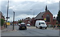
2
Pemberton Independent Methodist Church, Ormskirk Road
According to the Genuki page (https://www.genuki.org.uk/big/eng/LAN/Pemberton/OrmskirkRoadIndependentMethodist ) this was built in 1872.
Image: © David Dixon
Taken: 23 Jul 2019
0.17 miles
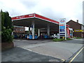
4
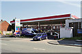
Spar Euro Garage, Pemberton
Esso filling station on Ormskirk Road.
Image: © David Dixon
Taken: 23 Jul 2019
0.18 miles
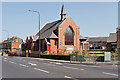
5
Lamberhead Green Independent Methodist Church on the junction of Ormskirk Road and Enfield Street
The steel and glass bollards on the right are 'street art'. They light up at night.
Image: © David Long
Taken: 18 Feb 2009
0.19 miles
6
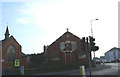
Lamberhead Green Independent Methodist Church
Image: © David Long
Taken: 20 Nov 2005
0.23 miles