IMAGES TAKEN NEAR TO
Laithwaite Road, WIGAN, WN5 9SA
Introduction
This page details the photographs taken nearby to Laithwaite Road, WN5 9SA by members of the Geograph project.
The Geograph project started in 2005 with the aim of publishing, organising and preserving representative images for every square kilometre of Great Britain, Ireland and the Isle of Man.

There are currently over 7.5m images from over14,400 individuals and you can help contribute to the project by visiting https://www.geograph.org.uk
Image Map
Images are licensed for reuse under creativecommons.org/licenses/by-sa/2.0
Notes
- Clicking on the map will re-center to the selected point.
- The higher the marker number, the further away the image location is from the centre of the postcode.
Image Listing (8 Images Found)
Images are licensed for reuse under creativecommons.org/licenses/by-sa/2.0
Image
Details
Distance
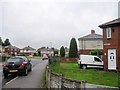
1
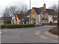
The Red Robin
Anjou Boulevard, Robin Park.
Image: © David Dixon
Taken: 5 Mar 2010
0.15 miles
2
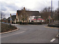
The Red Robin
Anjou Boulevard, Robin Park
Image: © David Dixon
Taken: 5 Mar 2010
0.16 miles
6
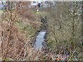
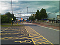
Close Brook and culvert
Between two car parks at the DW stadium.
Image: © David Dixon
Taken: 5 Mar 2010
0.21 miles
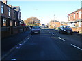
7
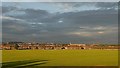
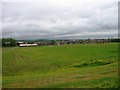
Wigan Skyline
View over Worsley Hall playing fields
Image: © Galatas
Taken: 23 Jul 2007
0.23 miles