IMAGES TAKEN NEAR TO
Ridyard Street, WIGAN, WN5 9QF
Introduction
This page details the photographs taken nearby to Ridyard Street, WN5 9QF by members of the Geograph project.
The Geograph project started in 2005 with the aim of publishing, organising and preserving representative images for every square kilometre of Great Britain, Ireland and the Isle of Man.

There are currently over 7.5m images from over14,400 individuals and you can help contribute to the project by visiting https://www.geograph.org.uk
Image Map
Images are licensed for reuse under creativecommons.org/licenses/by-sa/2.0
Notes
- Clicking on the map will re-center to the selected point.
- The higher the marker number, the further away the image location is from the centre of the postcode.
Image Listing (8 Images Found)
Images are licensed for reuse under creativecommons.org/licenses/by-sa/2.0
Image
Details
Distance
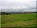
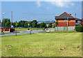
2

Wigan Skyline
View over Worsley Hall playing fields
Image: © Galatas
Taken: 23 Jul 2007
0.13 miles
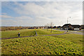
4
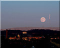
Moonrise 26th Dec 2004
Full moon rising over Winter Hill. Viewed from Worsley Hall Wigan
Image: © Galatas
Taken: 26 Dec 2004
0.19 miles