IMAGES TAKEN NEAR TO
Norley Hall Avenue, WIGAN, WN5 9LT
Introduction
This page details the photographs taken nearby to Norley Hall Avenue, WN5 9LT by members of the Geograph project.
The Geograph project started in 2005 with the aim of publishing, organising and preserving representative images for every square kilometre of Great Britain, Ireland and the Isle of Man.

There are currently over 7.5m images from over14,400 individuals and you can help contribute to the project by visiting https://www.geograph.org.uk
Image Map
Images are licensed for reuse under creativecommons.org/licenses/by-sa/2.0
Notes
- Clicking on the map will re-center to the selected point.
- The higher the marker number, the further away the image location is from the centre of the postcode.
Image Listing (10 Images Found)
Images are licensed for reuse under creativecommons.org/licenses/by-sa/2.0
Image
Details
Distance
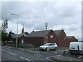
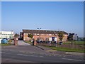
1
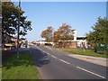
Montrose Avenue in Kitt Green
Viewed from Pemberton Business and Enterprise College seen on the right
Image: © Raymond Knapman
Taken: 13 Oct 2010
0.02 miles
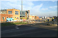
3
Entrance to PEMBAC on Montrose Avenue
PEMBAC is the Pemberton Business and Enterprise College
Image: © Raymond Knapman
Taken: 13 Oct 2010
0.09 miles
4
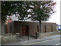
St Francis of Assisi, Kitt Green
Parts of the church building date from the 19th century, but it has a modern frontage
Image: © S Parish
Taken: 10 Oct 2008
0.19 miles