IMAGES TAKEN NEAR TO
Victoria Street, WIGAN, WN5 9BN
Introduction
This page details the photographs taken nearby to Victoria Street, WN5 9BN by members of the Geograph project.
The Geograph project started in 2005 with the aim of publishing, organising and preserving representative images for every square kilometre of Great Britain, Ireland and the Isle of Man.

There are currently over 7.5m images from over14,400 individuals and you can help contribute to the project by visiting https://www.geograph.org.uk
Image Map
Images are licensed for reuse under creativecommons.org/licenses/by-sa/2.0
Notes
- Clicking on the map will re-center to the selected point.
- The higher the marker number, the further away the image location is from the centre of the postcode.
Image Listing (30 Images Found)
Images are licensed for reuse under creativecommons.org/licenses/by-sa/2.0
Image
Details
Distance
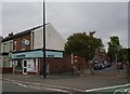
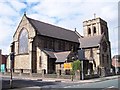
1
St Mark's Church
St Mark's vicarage and the church behind. Taken from the Warrington Road end of Argyll Street.
Image: © David Ashcroft
Taken: 3 Feb 2008
0.04 miles
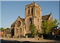
2
St Mark's church on Victoria Street
Image: © Raymond Knapman
Taken: 27 Jul 2010
0.05 miles
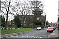
4
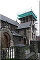
St Mark's Church
St Mark's church in the process of replacing its tower roof.
Image: © David Ashcroft
Taken: 3 Feb 2008
0.05 miles

7
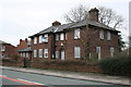
The old St Mark's Vicarage
The old vicarage opposite the church. Now replaced by a more modern building on the Worsley Hall estate.
Image: © David Ashcroft
Taken: 3 Feb 2008
0.06 miles