IMAGES TAKEN NEAR TO
Croft Avenue, WIGAN, WN5 8TW
Introduction
This page details the photographs taken nearby to Croft Avenue, WN5 8TW by members of the Geograph project.
The Geograph project started in 2005 with the aim of publishing, organising and preserving representative images for every square kilometre of Great Britain, Ireland and the Isle of Man.

There are currently over 7.5m images from over14,400 individuals and you can help contribute to the project by visiting https://www.geograph.org.uk
Image Map
Images are licensed for reuse under creativecommons.org/licenses/by-sa/2.0
Notes
- Clicking on the map will re-center to the selected point.
- The higher the marker number, the further away the image location is from the centre of the postcode.
Image Listing (40 Images Found)
Images are licensed for reuse under creativecommons.org/licenses/by-sa/2.0
Image
Details
Distance
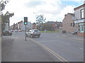
2
St James' Road, Far Moor
B5206 heading south west towards Billinge.
Image: © JThomas
Taken: 5 Jun 2014
0.07 miles
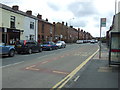
3
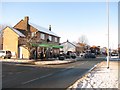
The Grapes
This crossroads on the B5206 is locally known as "the grapes" because there used to be a pub called the grapes here.
Image: © Gary Rogers
Taken: 27 Sep 2005
0.10 miles

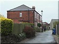
6
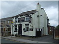
The Rose and Crown pub
On Church Street, Far Moor.
Image: © JThomas
Taken: 5 Jun 2014
0.12 miles
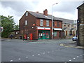
7
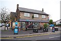
Welcome to Orrell's Co-op
Church Street, Orrell
Image: © Gary Rogers
Taken: 22 Nov 2016
0.14 miles
10

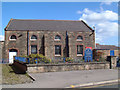
Orrell United Reformed Church on Church Road Orrell
Image: © Raymond Knapman
Taken: 19 Jul 2010
0.16 miles