IMAGES TAKEN NEAR TO
Delphside Close, WIGAN, WN5 8TS
Introduction
This page details the photographs taken nearby to Delphside Close, WN5 8TS by members of the Geograph project.
The Geograph project started in 2005 with the aim of publishing, organising and preserving representative images for every square kilometre of Great Britain, Ireland and the Isle of Man.

There are currently over 7.5m images from over14,400 individuals and you can help contribute to the project by visiting https://www.geograph.org.uk
Image Map
Images are licensed for reuse under creativecommons.org/licenses/by-sa/2.0
Notes
- Clicking on the map will re-center to the selected point.
- The higher the marker number, the further away the image location is from the centre of the postcode.
Image Listing (27 Images Found)
Images are licensed for reuse under creativecommons.org/licenses/by-sa/2.0
Image
Details
Distance
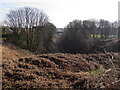
2
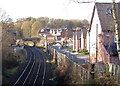
Upholland (1st) railway station (site), Lancashire
Opened in 1848 by the Lancashire and Yorkshire Railway on what became the line from Liverpool Exchange to Manchester Victoria via Wigan, this short-lived station closed in 1852. It was located just in front of the overbridge.
View west towards the current Upholland station (See Image]) and Liverpool.
Image: © Nigel Thompson
Taken: 24 Nov 2016
0.06 miles
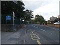
3

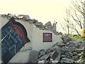
Demolishing the Sandbrook Arms
The Sandbrook Arms pub is now being demolished to make way for four new houses on Sandbrook Road, Tontine
Image: © Gary Rogers
Taken: 5 Feb 2015
0.07 miles
5
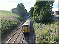
Train just exited Upholland Tunnel at Tontine heading for Wigan Wallgate
Image: © Gary Rogers
Taken: 1 Sep 2015
0.11 miles
6
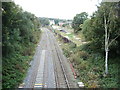
Wigan to Kirkby railway
A view of the Wigan to Kirkby railway line as it emerges from the tunnel into the Tontine area.
Image: © philip banks
Taken: 1 Mar 2012
0.11 miles
7
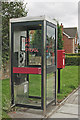
Use me please!
Graffiti on phone box on Sandbrook Road.
Image: © Gary Rogers
Taken: 16 Aug 2009
0.14 miles
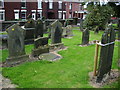
9
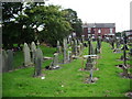
St James Roman Catholic Church, Orrell, Graveyard
This part of the graveyard is suffering a lot more of the prop up a gravestone syndrome
Image: © Alexander P Kapp
Taken: 30 Sep 2007
0.15 miles
10
St James Roman Catholic Church, Orrell, Graveyard
Each of the yellow stickers on the gravestones denotes a dangerous one, and the action of making one secure with post and plastic band
Image: © Alexander P Kapp
Taken: 30 Sep 2007
0.15 miles