IMAGES TAKEN NEAR TO
Fisher Drive, WIGAN, WN5 8QX
Introduction
This page details the photographs taken nearby to Fisher Drive, WN5 8QX by members of the Geograph project.
The Geograph project started in 2005 with the aim of publishing, organising and preserving representative images for every square kilometre of Great Britain, Ireland and the Isle of Man.

There are currently over 7.5m images from over14,400 individuals and you can help contribute to the project by visiting https://www.geograph.org.uk
Image Map
Images are licensed for reuse under creativecommons.org/licenses/by-sa/2.0
Notes
- Clicking on the map will re-center to the selected point.
- The higher the marker number, the further away the image location is from the centre of the postcode.
Image Listing (21 Images Found)
Images are licensed for reuse under creativecommons.org/licenses/by-sa/2.0
Image
Details
Distance
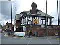
1
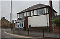
The Post at Orrell Post
Once used as a marker for the junction between ancient rights of way, the stone marker post nestles protected by the brick walls of the Stag Inn
Image: © David Hignett
Taken: 17 Aug 2005
0.05 miles
2
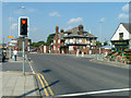
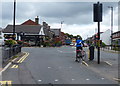
Orrell Post Crossroads
Standing at the Junction of the roads to Winstanley, Shevington, Up Holland and Wigan, the Stag Public House stands on the site of an ancient Inn.
Image: © David Hignett
Taken: 17 Aug 2005
0.05 miles
3
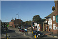
The Orrell Post, protected by the Stag
As seen from the top deck of the 375 Wigan - Southport bus.
Image: © David Long
Taken: 16 Oct 2009
0.05 miles

7

"The Stag Inn" Orrell Post, Orrell
Image: © Alexander P Kapp
Taken: 29 Jul 2007
0.07 miles
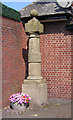
8

Old Guide Stone by the A577, Orrell Road, Orrell
Stone post by the A577, in parish of Orrell (Wigan District), Orrell Road, by The Stag pub.
Grade II listed.
List Entry Number: 1228432 https://historicengland.org.uk/listing/the-list/list-entry/1228432
Surveyed
Milestone Society National ID: LA_XORR
Image: © Milestone Society
Taken: Unknown
0.07 miles
9

Old Guide Stone by the A577, Orrell Road, Orrell
Stone post by the A577, in parish of Orrell (Wigan District), Orrell Road, by The Stag pub.
Grade II listed.
List Entry Number: 1228432 https://historicengland.org.uk/listing/the-list/list-entry/1228432
Surveyed
Milestone Society National ID: LA_XORR.
Image: © Christopher Leather
Taken: 29 Dec 2024
0.07 miles