IMAGES TAKEN NEAR TO
Oxford Road, WIGAN, WN5 8PQ
Introduction
This page details the photographs taken nearby to Oxford Road, WN5 8PQ by members of the Geograph project.
The Geograph project started in 2005 with the aim of publishing, organising and preserving representative images for every square kilometre of Great Britain, Ireland and the Isle of Man.

There are currently over 7.5m images from over14,400 individuals and you can help contribute to the project by visiting https://www.geograph.org.uk
Image Map
Images are licensed for reuse under creativecommons.org/licenses/by-sa/2.0
Notes
- Clicking on the map will re-center to the selected point.
- The higher the marker number, the further away the image location is from the centre of the postcode.
Image Listing (16 Images Found)
Images are licensed for reuse under creativecommons.org/licenses/by-sa/2.0
Image
Details
Distance
1
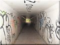
Tiled Subway under M6 Motorway at Orrell
Image: © Gary Rogers
Taken: 13 Oct 2014
0.06 miles
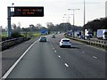
3
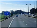
M6 Southbound Matrix Sign from footpath between Kitt Green and Orrell Post
Image: © Gary Rogers
Taken: 13 Oct 2014
0.08 miles
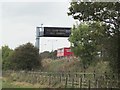
6
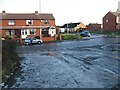
Gathurst Road
Looking over Gathurst Road, Orrell towards Derwent Road.
Image: © Richard Webb
Taken: 27 Dec 2009
0.15 miles
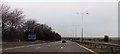
8
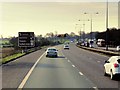
Orrell : M6 Motorway
The M6 Motorway between Junction 26 (Orrell Interchange) and Junction 27.
Image: © Lewis Clarke
Taken: 23 Sep 2019
0.16 miles
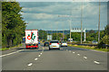
9
Gathurst Road (B5206). Orrell
Heading south.
Image: © JThomas
Taken: 5 Jun 2014
0.17 miles