IMAGES TAKEN NEAR TO
Priory Close, WIGAN, WN5 8JX
Introduction
This page details the photographs taken nearby to Priory Close, WN5 8JX by members of the Geograph project.
The Geograph project started in 2005 with the aim of publishing, organising and preserving representative images for every square kilometre of Great Britain, Ireland and the Isle of Man.

There are currently over 7.5m images from over14,400 individuals and you can help contribute to the project by visiting https://www.geograph.org.uk
Image Map
Images are licensed for reuse under creativecommons.org/licenses/by-sa/2.0
Notes
- Clicking on the map will re-center to the selected point.
- The higher the marker number, the further away the image location is from the centre of the postcode.
Image Listing (21 Images Found)
Images are licensed for reuse under creativecommons.org/licenses/by-sa/2.0
Image
Details
Distance
1
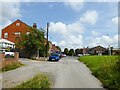
Brook Lane
The track Brook Lane is approaching the modern Brook Lane. The two confusingly run parallel for a distance behind the camera.
Image: © Kevin Waterhouse
Taken: 30 Jul 2024
0.07 miles
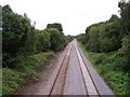
2
South of Lamberhead Green
the view from the bridge looking east towards Highfield.
Image: © Gary Rogers
Taken: 1 Sep 2005
0.14 miles
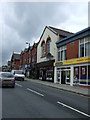
3
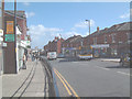
Pemberton
looking east along the A577 through the central shopping area.
Image: © Gary Rogers
Taken: 27 Sep 2005
0.16 miles
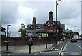
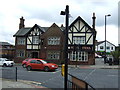
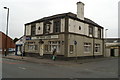
6
The White Swan, Pemberton
Large public house on Ormskirk Road.
Image: © David Dixon
Taken: 23 Jul 2019
0.18 miles
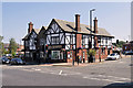
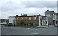
8
The White Lion, Ormskirk Road, Pemberton
Image: © David Long
Taken: 18 Feb 2009
0.21 miles
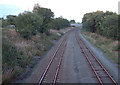
9
Wigan to Kirkby railway from bridge at Winstanley Hall estate
Viewed towards Wigan
Image: © Raymond Knapman
Taken: 27 Jul 2010
0.21 miles
10
Post Office and shop on Fleet Street, Lamberhead Green
Image: © JThomas
Taken: 5 Jun 2014
0.22 miles