IMAGES TAKEN NEAR TO
Milton Grove, WIGAN, WN5 8HT
Introduction
This page details the photographs taken nearby to Milton Grove, WN5 8HT by members of the Geograph project.
The Geograph project started in 2005 with the aim of publishing, organising and preserving representative images for every square kilometre of Great Britain, Ireland and the Isle of Man.

There are currently over 7.5m images from over14,400 individuals and you can help contribute to the project by visiting https://www.geograph.org.uk
Image Map
Images are licensed for reuse under creativecommons.org/licenses/by-sa/2.0
Notes
- Clicking on the map will re-center to the selected point.
- The higher the marker number, the further away the image location is from the centre of the postcode.
Image Listing (15 Images Found)
Images are licensed for reuse under creativecommons.org/licenses/by-sa/2.0
Image
Details
Distance
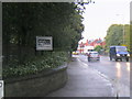
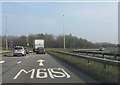
1
Pick your motorway
Lane markings for north, south and west at the eastern roundabout of the M6's junction 26.
Image: © Peter Whatley
Taken: 23 Mar 2012
0.12 miles
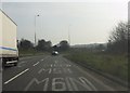
2
M6 jn26 Orrell slip road.
from the footbridge.
Image: © Gary Rogers
Taken: 28 Oct 2013
0.16 miles
3
M6 jn26 Orrell slip road.
from the footbridge
Image: © Gary Rogers
Taken: 28 Oct 2013
0.16 miles
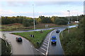
4
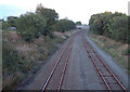
South of Lamberhead Green
the view from the bridge looking east towards Highfield.
Image: © Gary Rogers
Taken: 1 Sep 2005
0.17 miles
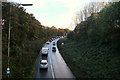
7
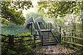
Footbridge over Orrell sliproad M6 jn26
Image: © Gary Rogers
Taken: 28 Oct 2013
0.18 miles
8
M6 motorway - eastern roundabout, junction 26
Image: © Peter Whatley
Taken: 23 Mar 2012
0.19 miles
9
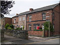
Calderbank
Row of cottages on the route of an old road
Image: © Rob Rylands
Taken: 25 Jul 2007
0.19 miles