IMAGES TAKEN NEAR TO
Sandford Road, WIGAN, WN5 8FS
Introduction
This page details the photographs taken nearby to Sandford Road, WN5 8FS by members of the Geograph project.
The Geograph project started in 2005 with the aim of publishing, organising and preserving representative images for every square kilometre of Great Britain, Ireland and the Isle of Man.

There are currently over 7.5m images from over14,400 individuals and you can help contribute to the project by visiting https://www.geograph.org.uk
Image Map
Images are licensed for reuse under creativecommons.org/licenses/by-sa/2.0
Notes
- Clicking on the map will re-center to the selected point.
- The higher the marker number, the further away the image location is from the centre of the postcode.
Image Listing (25 Images Found)
Images are licensed for reuse under creativecommons.org/licenses/by-sa/2.0
Image
Details
Distance
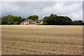
3

Farm track entrance leads to Higher Pimbo Farm
Image: © Raymond Knapman
Taken: 19 Jul 2010
0.08 miles

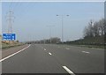
6

Telecommunications mast and pylon straddle the M58 near Lawns Farm
Image: © Raymond Knapman
Taken: 19 Jul 2010
0.11 miles
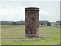
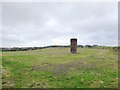
10
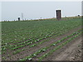
Airshafts over Upholland Railway Tunnel
Image: © Peter Wood
Taken: 12 Aug 2012
0.15 miles