IMAGES TAKEN NEAR TO
Ellis Road, WIGAN, WN5 7TR
Introduction
This page details the photographs taken nearby to Ellis Road, WN5 7TR by members of the Geograph project.
The Geograph project started in 2005 with the aim of publishing, organising and preserving representative images for every square kilometre of Great Britain, Ireland and the Isle of Man.

There are currently over 7.5m images from over14,400 individuals and you can help contribute to the project by visiting https://www.geograph.org.uk
Image Map
Images are licensed for reuse under creativecommons.org/licenses/by-sa/2.0
Notes
- Clicking on the map will re-center to the selected point.
- The higher the marker number, the further away the image location is from the centre of the postcode.
Image Listing (54 Images Found)
Images are licensed for reuse under creativecommons.org/licenses/by-sa/2.0
Image
Details
Distance
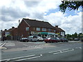
2
Main Street - Billinge
View Northeast from the sharp bend on the A571. The flat roofed buildings on the left are shops with flats above and the stone building on the right is now occupied by Romancia, a wedding dress shop.
Image: © Gary Rogers
Taken: 18 Jan 2006
0.12 miles
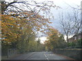

8
Carr Mill Road, Billinge
Towards Chadwick Green.
Image: © JThomas
Taken: 5 Jun 2014
0.16 miles