IMAGES TAKEN NEAR TO
Ribble Crescent, WIGAN, WN5 7QX
Introduction
This page details the photographs taken nearby to Ribble Crescent, WN5 7QX by members of the Geograph project.
The Geograph project started in 2005 with the aim of publishing, organising and preserving representative images for every square kilometre of Great Britain, Ireland and the Isle of Man.

There are currently over 7.5m images from over14,400 individuals and you can help contribute to the project by visiting https://www.geograph.org.uk
Image Map
Images are licensed for reuse under creativecommons.org/licenses/by-sa/2.0
Notes
- Clicking on the map will re-center to the selected point.
- The higher the marker number, the further away the image location is from the centre of the postcode.
Image Listing (18 Images Found)
Images are licensed for reuse under creativecommons.org/licenses/by-sa/2.0
Image
Details
Distance
1
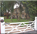
Turners Fold
nicest house in Billinge? ......probably!
Image: © Gary Rogers
Taken: 31 Aug 2005
0.09 miles
2
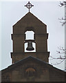
The Bell Tower on St Mary's
The Bell Tower on St Mary's Church, Birchley.
Image: © Gary Rogers
Taken: 18 Jan 2006
0.09 miles
4
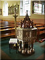
Birchley, St Mary's Catholic Church, Font
Image: © Alexander P Kapp
Taken: 30 Sep 2007
0.13 miles
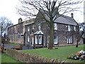
5
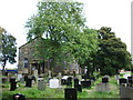
Birchley, St Mary's Catholic Church
Image: © Alexander P Kapp
Taken: 30 Sep 2007
0.13 miles
6
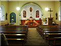
Birchley, St Mary's Catholic Church, Interior
Image: © Alexander P Kapp
Taken: 30 Sep 2007
0.14 miles
7
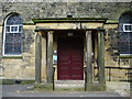
Birchley, St Mary's Catholic Church, Porch
Image: © Alexander P Kapp
Taken: 30 Sep 2007
0.14 miles
8
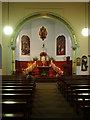
Birchley, St Mary's Catholic Church, Interior
Image: © Alexander P Kapp
Taken: 30 Sep 2007
0.14 miles