IMAGES TAKEN NEAR TO
Fair View, WIGAN, WN5 7NZ
Introduction
This page details the photographs taken nearby to Fair View, WN5 7NZ by members of the Geograph project.
The Geograph project started in 2005 with the aim of publishing, organising and preserving representative images for every square kilometre of Great Britain, Ireland and the Isle of Man.

There are currently over 7.5m images from over14,400 individuals and you can help contribute to the project by visiting https://www.geograph.org.uk
Image Map
Images are licensed for reuse under creativecommons.org/licenses/by-sa/2.0
Notes
- Clicking on the map will re-center to the selected point.
- The higher the marker number, the further away the image location is from the centre of the postcode.
Image Listing (96 Images Found)
Images are licensed for reuse under creativecommons.org/licenses/by-sa/2.0
Image
Details
Distance
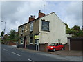
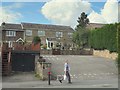
1
Footpath between Sefton Fold Drive and Fairview Avenue, Billinge
Image: © Gary Rogers
Taken: 29 Sep 2014
0.03 miles
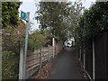
2
Housing development on Main Street, Billinge
Image: © Gary Rogers
Taken: 15 Mar 2017
0.06 miles
3
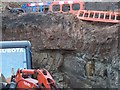
Main Street Geology
Clay and sandstone exposed during excavations for a new development on Main Street, Billinge
Image: © Gary Rogers
Taken: 17 Sep 2016
0.06 miles
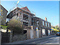
4
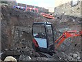
Excavations
Digging foundations for a new development next to an old stone house on Main Street
Image: © Gary Rogers
Taken: 17 Sep 2016
0.06 miles
7

Joint Churches' Annual Parade, Billinge. 2014
Image: © Gary Rogers
Taken: 29 Jun 2014
0.07 miles
8
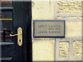
Mr T. Saxon, Dental Surgeon
Main Street, Billinge.
Image: © Gary Rogers
Taken: 7 May 2014
0.07 miles
9
Rented Flats, Main Street, Billinge
Rented Flats with off road parking for residents only.
Image: © Gary Rogers
Taken: 20 Aug 2014
0.08 miles