IMAGES TAKEN NEAR TO
Crank Road, WIGAN, WN5 7DT
Introduction
This page details the photographs taken nearby to Crank Road, WN5 7DT by members of the Geograph project.
The Geograph project started in 2005 with the aim of publishing, organising and preserving representative images for every square kilometre of Great Britain, Ireland and the Isle of Man.

There are currently over 7.5m images from over14,400 individuals and you can help contribute to the project by visiting https://www.geograph.org.uk
Image Map
Images are licensed for reuse under creativecommons.org/licenses/by-sa/2.0
Notes
- Clicking on the map will re-center to the selected point.
- The higher the marker number, the further away the image location is from the centre of the postcode.
Image Listing (49 Images Found)
Images are licensed for reuse under creativecommons.org/licenses/by-sa/2.0
Image
Details
Distance
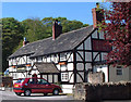
1
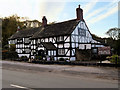
Longshaw, Holts Arms
Public house on Crank Road
Image: © David Dixon
Taken: 28 Oct 2019
0.02 miles
2
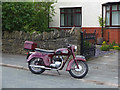
Triumph Speed Twin
Probably out visiting on Crank Road, Billinge
Image: © Gary Rogers
Taken: 29 Jul 2017
0.03 miles

6
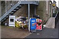
Outside Londis, Upholland Road, Billinge
Image: © Gary Rogers
Taken: 22 Nov 2016
0.06 miles
8
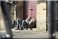
Benchmarker
Entrance to Bispham Methodist Church at the junction of Upholland Road and Crank Road.
Image: © Gary Rogers
Taken: 12 Mar 2014
0.06 miles
9
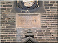
Date Stone on Methodist Chapel, Billinge
inscription reads: Wesleyan Methodist Chapel, Erected 1845 by Wm Holt, Bispham Hall.
Image: © Gary Rogers
Taken: 2 May 2007
0.07 miles
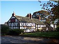
10
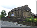
Bispham Methodist Church
On Upholland Road.
Image: © JThomas
Taken: 5 Jun 2014
0.07 miles