IMAGES TAKEN NEAR TO
Greenslate Road, WIGAN, WN5 7BG
Introduction
This page details the photographs taken nearby to Greenslate Road, WN5 7BG by members of the Geograph project.
The Geograph project started in 2005 with the aim of publishing, organising and preserving representative images for every square kilometre of Great Britain, Ireland and the Isle of Man.

There are currently over 7.5m images from over14,400 individuals and you can help contribute to the project by visiting https://www.geograph.org.uk
Image Map
Images are licensed for reuse under creativecommons.org/licenses/by-sa/2.0
Notes
- Clicking on the map will re-center to the selected point.
- The higher the marker number, the further away the image location is from the centre of the postcode.
Image Listing (18 Images Found)
Images are licensed for reuse under creativecommons.org/licenses/by-sa/2.0
Image
Details
Distance
1
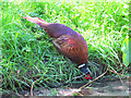
Pheasant drinking at Greenslate Water Meadows
Image: © Gary Rogers
Taken: 4 May 2017
0.09 miles
2
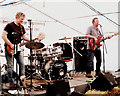
Hollow Dog at Greenfest 2015
Local band Hollow Dog playing at Greenfest at Greenslate Community Farm, Billinge
Image: © Gary Rogers
Taken: 1 Aug 2015
0.11 miles
3
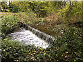
Weir on Smithy Brook at Orrell Water Park
Smithy Brook is a tributary of the River Douglas.
Image: © David Dixon
Taken: 27 Oct 2019
0.11 miles
6
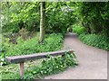
Path at Greenslate Water Meadow
Leading back to Tracks Lane
Image: © Gary Rogers
Taken: 18 May 2010
0.14 miles
7
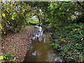
Smithy Brook at Greenslate Water Meadows
Smithy Brook is a tributary of the River Douglas. The Greenslate Water Meadows local nature reserve is an area of wetland and woodland to the south of the two lakes at Orrell Water Park. Greenslate meadows reserve provides a mixture of open water, swamp, wet woodland, scrub, native trees surrounded by well-established hedgerows.
https://ww2.rspb.org.uk/groups/Liverpool/places/342104/ RSPB Liverpool Local Group
Image: © David Dixon
Taken: 27 Oct 2019
0.14 miles
8
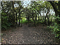
Footpath, Greenslate Water Meadows
The Greenslate Water Meadows local nature reserve is an area of wetland and woodland to the south of the two lakes at Orrell Water Park. Greenslate meadows reserve provides a mixture of open water, swamp, wet woodland, scrub, native trees surrounded by well-established hedgerows.
https://ww2.rspb.org.uk/groups/Liverpool/places/342104/ RSPB Liverpool Local Group
Image: © David Dixon
Taken: 27 Oct 2019
0.16 miles
9
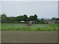
Crop spraying in fields near Winstanley College
Image: © Gary Rogers
Taken: 20 May 2010
0.17 miles
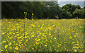
10
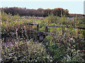
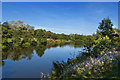
Greenslate Water Meadows
The Greenslate Water Meadows local nature reserve is an area of wetland and woodland to the south of the two lakes at Orrell Water Park. Greenslate meadows reserve provides a mixture of open water, swamp, wet woodland, scrub, native trees surrounded by well-established hedgerows.
https://ww2.rspb.org.uk/groups/Liverpool/places/342104/ RSPB Liverpool Local Group
Image: © David Dixon
Taken: 27 Oct 2019
0.18 miles