IMAGES TAKEN NEAR TO
Old Station Court, WIGAN, WN5 7AP
Introduction
This page details the photographs taken nearby to Old Station Court, WN5 7AP by members of the Geograph project.
The Geograph project started in 2005 with the aim of publishing, organising and preserving representative images for every square kilometre of Great Britain, Ireland and the Isle of Man.

There are currently over 7.5m images from over14,400 individuals and you can help contribute to the project by visiting https://www.geograph.org.uk
Image Map
Images are licensed for reuse under creativecommons.org/licenses/by-sa/2.0
Notes
- Clicking on the map will re-center to the selected point.
- The higher the marker number, the further away the image location is from the centre of the postcode.
Image Listing (57 Images Found)
Images are licensed for reuse under creativecommons.org/licenses/by-sa/2.0
Image
Details
Distance

3
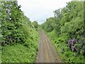
Railway towards Wigan
View from the road bridge by Orrell railway station
Image: © Kevin Waterhouse
Taken: 24 May 2024
0.04 miles
4
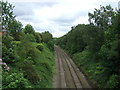
Railway heading east
From Orrell Railway Station towards Wigan.
Image: © JThomas
Taken: 5 Jun 2014
0.04 miles
5
New houses being built right next to the railway line
Image: © Ian Greig
Taken: 3 May 2010
0.06 miles
6

Fungus, Orrell Water Park
This was a good 9 or 10 inches tall.
Image: © Gary Rogers
Taken: 28 Oct 2013
0.06 miles
7
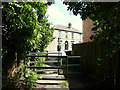
Path between St James Road and Church Street, Orrell
Image: © Gary Rogers
Taken: 7 Aug 2015
0.06 miles
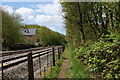
9
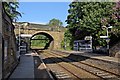
Wigan-bound platform, Orrell railway station
The Church Street road bridge is at the end of the platform.
Image: © El Pollock
Taken: 18 Jun 2015
0.07 miles
10
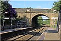
Church Street bridge, Orrell railway station
At the eastern end of the platform.
Image: © El Pollock
Taken: 18 Jun 2015
0.07 miles