IMAGES TAKEN NEAR TO
Wallgate, WIGAN, WN5 0XG
Introduction
This page details the photographs taken nearby to Wallgate, WN5 0XG by members of the Geograph project.
The Geograph project started in 2005 with the aim of publishing, organising and preserving representative images for every square kilometre of Great Britain, Ireland and the Isle of Man.

There are currently over 7.5m images from over14,400 individuals and you can help contribute to the project by visiting https://www.geograph.org.uk
Image Map
Images are licensed for reuse under creativecommons.org/licenses/by-sa/2.0
Notes
- Clicking on the map will re-center to the selected point.
- The higher the marker number, the further away the image location is from the centre of the postcode.
Image Listing (97 Images Found)
Images are licensed for reuse under creativecommons.org/licenses/by-sa/2.0
Image
Details
Distance
1
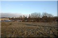
Kwik Fit premises
Proposed route of new road from Saddle Junction to Frog Lane
Image: © Galatas
Taken: 24 Jan 2011
0.01 miles
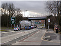
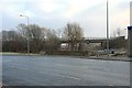
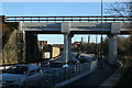
3
A quiet moment at Wigan's bottleneck
The railway bridge at the Saddle roundabout
Image: © Raymond Knapman
Taken: 27 Jul 2010
0.04 miles
4
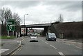
Bridge at Saddle Junction
Notorious bottleneck on A49 south of Wigan town centre. Millions spent on the Saddle junction wasted for want of widening this bridge.
Image: © Galatas
Taken: 3 Feb 2008
0.05 miles
5
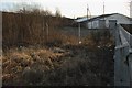
At the rear of Kwik Fit garage
A new road is proposed alongside the railway behind Kwik Fit's premises.
Image: © Galatas
Taken: 24 Jan 2011
0.06 miles
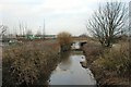
6
Footpaths under viaduct
Footpaths either side of the river Douglas, under this viaduct, lead to Swan Meadow and Parson's Meadow. There are plans for a new road to join Saddle Junction at this point.
Image: © Galatas
Taken: 22 Jan 2011
0.06 miles
8
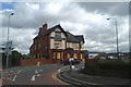
Fallen Stars
Sadly, the Seven Stars has joined the list of pubs around the perimeter of Wigan Town Centre which have closed.
Image: © David Long
Taken: 10 Jul 2008
0.08 miles
9
Adam Viaduct
A new road called "Southgate" was opened to traffic on 26th November 2012.
See this photo for the bridge prior to the road: http://www.geograph.org.uk/photo/1595590
Image: © David Ashcroft
Taken: 1 Dec 2012
0.08 miles
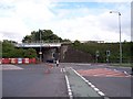
10
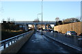
Southgate
A new road opened to traffic on 26th November 2012.
See this photo for the same view prior to the road being built:
http://www.geograph.org.uk/photo/1595600
Image: © David Ashcroft
Taken: 1 Dec 2012
0.08 miles