IMAGES TAKEN NEAR TO
Stranraer Road, WIGAN, WN5 0QZ
Introduction
This page details the photographs taken nearby to Stranraer Road, WN5 0QZ by members of the Geograph project.
The Geograph project started in 2005 with the aim of publishing, organising and preserving representative images for every square kilometre of Great Britain, Ireland and the Isle of Man.

There are currently over 7.5m images from over14,400 individuals and you can help contribute to the project by visiting https://www.geograph.org.uk
Image Map
Images are licensed for reuse under creativecommons.org/licenses/by-sa/2.0
Notes
- Clicking on the map will re-center to the selected point.
- The higher the marker number, the further away the image location is from the centre of the postcode.
Image Listing (6 Images Found)
Images are licensed for reuse under creativecommons.org/licenses/by-sa/2.0
Image
Details
Distance
1
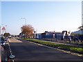
Playground on Kitt Green Road
Marsh Green shopping parade in background
Image: © Raymond Knapman
Taken: 13 Oct 2010
0.12 miles
2
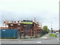
Kitt Green Mews
A new housing development on Blenheim Road, Kitt Green, Wigan
Image: © Gary Rogers
Taken: 13 Oct 2014
0.14 miles

5
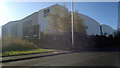
Torque Logistics, Marsh Green
This warehouse, on Challenge Way, is a Torque Logistics distribution centre (formerly belonging to JJB Sports), and is located in the Marsh Green area of Wigan, Greater Manchester, England.
Image: © Steven Haslington
Taken: 5 Nov 2012
0.24 miles