IMAGES TAKEN NEAR TO
Sheraton Close, WIGAN, WN5 0HB
Introduction
This page details the photographs taken nearby to Sheraton Close, WN5 0HB by members of the Geograph project.
The Geograph project started in 2005 with the aim of publishing, organising and preserving representative images for every square kilometre of Great Britain, Ireland and the Isle of Man.

There are currently over 7.5m images from over14,400 individuals and you can help contribute to the project by visiting https://www.geograph.org.uk
Image Map
Images are licensed for reuse under creativecommons.org/licenses/by-sa/2.0
Notes
- Clicking on the map will re-center to the selected point.
- The higher the marker number, the further away the image location is from the centre of the postcode.
Image Listing (8 Images Found)
Images are licensed for reuse under creativecommons.org/licenses/by-sa/2.0
Image
Details
Distance
4
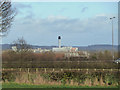
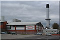
Heinz factory at Kitt Green from Gathurst Road
Image: © Gary Rogers
Taken: 24 Feb 2015
0.17 miles
5
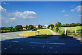
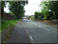
Spring Road from Latham Lane
The Heinz plant is in the background
Image: © Ian Greig
Taken: 17 Jun 2010
0.17 miles
7
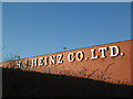
H J Heinz
Where the beans come from!
The Heinz factory dominates this square but there is a pleasant woodland area to the North.
Image: © Gary Rogers
Taken: 27 Jun 2005
0.21 miles