IMAGES TAKEN NEAR TO
Arnside Road, WIGAN, WN5 0DD
Introduction
This page details the photographs taken nearby to Arnside Road, WN5 0DD by members of the Geograph project.
The Geograph project started in 2005 with the aim of publishing, organising and preserving representative images for every square kilometre of Great Britain, Ireland and the Isle of Man.

There are currently over 7.5m images from over14,400 individuals and you can help contribute to the project by visiting https://www.geograph.org.uk
Image Map
Images are licensed for reuse under creativecommons.org/licenses/by-sa/2.0
Notes
- Clicking on the map will re-center to the selected point.
- The higher the marker number, the further away the image location is from the centre of the postcode.
Image Listing (16 Images Found)
Images are licensed for reuse under creativecommons.org/licenses/by-sa/2.0
Image
Details
Distance
4
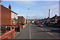
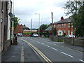
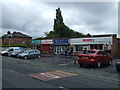
The City Road to the country
Wigan, once a place of heavy industry and mining, is surrounded by lovely countryside - vistas of which pop into view unexpectedly as you round a bend, or reach a high spot where you can look out over the tops of houses and mills.
Image: © David Long
Taken: 13 Mar 2007
0.21 miles