IMAGES TAKEN NEAR TO
Balliol Way, WIGAN, WN4 9RD
Introduction
This page details the photographs taken nearby to Balliol Way, WN4 9RD by members of the Geograph project.
The Geograph project started in 2005 with the aim of publishing, organising and preserving representative images for every square kilometre of Great Britain, Ireland and the Isle of Man.

There are currently over 7.5m images from over14,400 individuals and you can help contribute to the project by visiting https://www.geograph.org.uk
Image Map
Images are licensed for reuse under creativecommons.org/licenses/by-sa/2.0
Notes
- Clicking on the map will re-center to the selected point.
- The higher the marker number, the further away the image location is from the centre of the postcode.
Image Listing (26 Images Found)
Images are licensed for reuse under creativecommons.org/licenses/by-sa/2.0
Image
Details
Distance
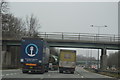
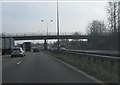
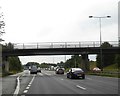
1
M6 motorway south of Low Bank Road bridge
Image: © Peter Whatley
Taken: 23 Mar 2012
0.11 miles
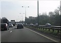
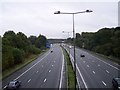
2
Metropolitan Borough of Wigan : The M6 Motorway
Heading northbound on the M6 Motorway through the Metropolitan Borough of Wigan.
Image: © Lewis Clarke
Taken: 21 Apr 2016
0.13 miles
5
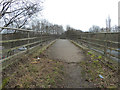
Footbridge over M6 at Long Covert, Downall Green
Image: © Gary Rogers
Taken: 13 Feb 2015
0.13 miles
6
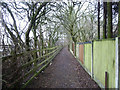
Footpath parallel to M6 at Long Covert, Downall Green
Image: © Gary Rogers
Taken: 13 Feb 2015
0.13 miles
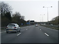
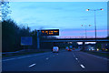
8
The M6 viewed south from Spindle Hillock road bridge
Image: © Raymond Knapman
Taken: 10 Sep 2010
0.14 miles
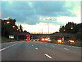
9
Footpath and access bridge over M6 at J24 southbound
Image: © David Smith
Taken: 7 Oct 2016
0.14 miles