IMAGES TAKEN NEAR TO
Osborne Road, WIGAN, WN4 9QJ
Introduction
This page details the photographs taken nearby to Osborne Road, WN4 9QJ by members of the Geograph project.
The Geograph project started in 2005 with the aim of publishing, organising and preserving representative images for every square kilometre of Great Britain, Ireland and the Isle of Man.

There are currently over 7.5m images from over14,400 individuals and you can help contribute to the project by visiting https://www.geograph.org.uk
Image Map
Images are licensed for reuse under creativecommons.org/licenses/by-sa/2.0
Notes
- Clicking on the map will re-center to the selected point.
- The higher the marker number, the further away the image location is from the centre of the postcode.
Image Listing (10 Images Found)
Images are licensed for reuse under creativecommons.org/licenses/by-sa/2.0
Image
Details
Distance

6
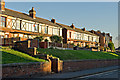
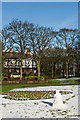
Tudor Style Housing, Wigan Road
Opposite Ashton Library
Image: © Dave Green
Taken: 14 Nov 2007
0.22 miles
8
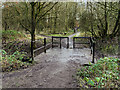
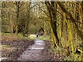
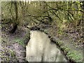
Skitters Wood, Bridge over Millingford Brook
Image: © David Dixon
Taken: 22 Jan 2016
0.23 miles
10
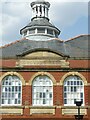
Carnegie Library and Lecture Hall, Ashton-in-Makerfield – detail
Built in 1905-6 to a design by the architects J B & W Thornely. The lecture hall was later converted to a children's library. Listed Grade II.
Image: © Alan Murray-Rust
Taken: 13 Jun 2023
0.25 miles