IMAGES TAKEN NEAR TO
Willowfield Grove, WIGAN, WN4 9NN
Introduction
This page details the photographs taken nearby to Willowfield Grove, WN4 9NN by members of the Geograph project.
The Geograph project started in 2005 with the aim of publishing, organising and preserving representative images for every square kilometre of Great Britain, Ireland and the Isle of Man.

There are currently over 7.5m images from over14,400 individuals and you can help contribute to the project by visiting https://www.geograph.org.uk
Image Map
Images are licensed for reuse under creativecommons.org/licenses/by-sa/2.0
Notes
- Clicking on the map will re-center to the selected point.
- The higher the marker number, the further away the image location is from the centre of the postcode.
Image Listing (15 Images Found)
Images are licensed for reuse under creativecommons.org/licenses/by-sa/2.0
Image
Details
Distance
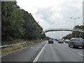
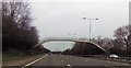
4
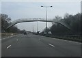
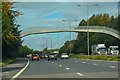
M6 Footbridge, Ashton-in-Makerfield
The footbridge near to Byrchall High School.
Image: © David Dixon
Taken: 17 Sep 2010
0.16 miles
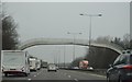
5
Footbridge over M6 near Byrchall High School
Image: © David Smith
Taken: 7 Oct 2016
0.16 miles
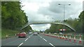
9
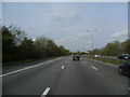
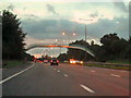
Ashton-in-Makerfield : M6 Motorway
The M6 Motorway between Junction 23 (Haydock) and Junction 24.
Image: © Lewis Clarke
Taken: 23 Sep 2019
0.20 miles
