IMAGES TAKEN NEAR TO
Dawley Close, WIGAN, WN4 9LA
Introduction
This page details the photographs taken nearby to Dawley Close, WN4 9LA by members of the Geograph project.
The Geograph project started in 2005 with the aim of publishing, organising and preserving representative images for every square kilometre of Great Britain, Ireland and the Isle of Man.

There are currently over 7.5m images from over14,400 individuals and you can help contribute to the project by visiting https://www.geograph.org.uk
Image Map
Images are licensed for reuse under creativecommons.org/licenses/by-sa/2.0
Notes
- Clicking on the map will re-center to the selected point.
- The higher the marker number, the further away the image location is from the centre of the postcode.
Image Listing (14 Images Found)
Images are licensed for reuse under creativecommons.org/licenses/by-sa/2.0
Image
Details
Distance
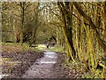
1
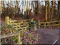
Entrance to Skitters Wood from Woodedge
Image: © David Dixon
Taken: 22 Jan 2016
0.11 miles
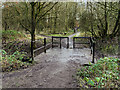
2
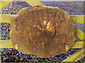
Skitters Wood Sign
Sign on the gate shown in Image
Image: © David Dixon
Taken: 22 Jan 2016
0.11 miles
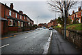
3
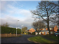
Houghwood Grange, Ashton-in-Makerfield
Very close to the M6.
Image: © Karl and Ali
Taken: 25 Dec 2011
0.14 miles
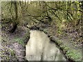
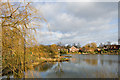
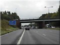
6
Skitters Wood, Bridge over Millingford Brook
Image: © David Dixon
Taken: 22 Jan 2016
0.19 miles
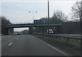
10
A58 bridge over M6 at J24
Because this junction has limited access (exit southbound, access northbound) there is only one bridge over the M6 here
Image: © David Smith
Taken: 7 Oct 2016
0.23 miles