IMAGES TAKEN NEAR TO
Laburnam Street, WIGAN, WN4 9EH
Introduction
This page details the photographs taken nearby to Laburnam Street, WN4 9EH by members of the Geograph project.
The Geograph project started in 2005 with the aim of publishing, organising and preserving representative images for every square kilometre of Great Britain, Ireland and the Isle of Man.

There are currently over 7.5m images from over14,400 individuals and you can help contribute to the project by visiting https://www.geograph.org.uk
Image Map
Images are licensed for reuse under creativecommons.org/licenses/by-sa/2.0
Notes
- Clicking on the map will re-center to the selected point.
- The higher the marker number, the further away the image location is from the centre of the postcode.
Image Listing (56 Images Found)
Images are licensed for reuse under creativecommons.org/licenses/by-sa/2.0
Image
Details
Distance

4
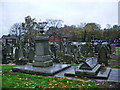
St Thomas Church, Ashton-in-Makerfield, Graveyard
Image: © Alexander P Kapp
Taken: 6 Nov 2007
0.11 miles
5
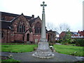
St Thomas Church, Ashton-in-Makerfield, War Memorial
Image: © Alexander P Kapp
Taken: 6 Nov 2007
0.12 miles
8
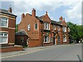
The Commercial Hotel, Heath Road, Ashton-in-Makerfield
Red brick and terracotta pub, built 1901.
Image: © Alan Murray-Rust
Taken: 13 Jun 2023
0.13 miles
9
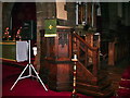
St Thomas Church, Ashton-in-Makerfield, Pulpit
Image: © Alexander P Kapp
Taken: 6 Nov 2007
0.13 miles
10
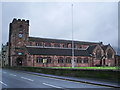
St Thomas Church, Ashton-in-Makerfield
Image: © Alexander P Kapp
Taken: 6 Nov 2007
0.13 miles