IMAGES TAKEN NEAR TO
Diane Road, WIGAN, WN4 8SY
Introduction
This page details the photographs taken nearby to Diane Road, WN4 8SY by members of the Geograph project.
The Geograph project started in 2005 with the aim of publishing, organising and preserving representative images for every square kilometre of Great Britain, Ireland and the Isle of Man.

There are currently over 7.5m images from over14,400 individuals and you can help contribute to the project by visiting https://www.geograph.org.uk
Image Map
Images are licensed for reuse under creativecommons.org/licenses/by-sa/2.0
Notes
- Clicking on the map will re-center to the selected point.
- The higher the marker number, the further away the image location is from the centre of the postcode.
Image Listing (12 Images Found)
Images are licensed for reuse under creativecommons.org/licenses/by-sa/2.0
Image
Details
Distance
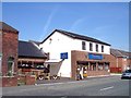
1
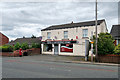
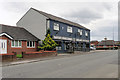
Stubshaw Cross News and Convenience Store
Bolton Road, Stubshaw Cross
Image: © David Dixon
Taken: 21 Jul 2019
0.09 miles
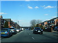
2
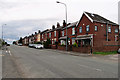
Stubshaw Cross, Terraced Houses on Bolton Road
Image: © David Dixon
Taken: 21 Jul 2019
0.09 miles
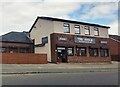
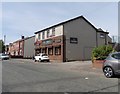
4
Barton's Wines and Spirits, Bolton Road, Stubshaw Cross
Image: © David Dixon
Taken: 21 Jul 2019
0.10 miles
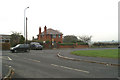
6
Triangle Snooker Club at Stubshaw Cross
Image: © Anthony Parkes
Taken: 21 Aug 2023
0.14 miles
8
Triangle Snooker Club, Stubshaw Cross
Image: © Roger Cornfoot
Taken: 23 Jun 2018
0.14 miles
9
The Triangle Snooker Club at Stubshaw Cross
Image: © Raymond Knapman
Taken: 1 Sep 2010
0.15 miles